4 months after coming back, here is the full tale of our World Trip! We used Polarsteps as our journal, writing down all our adventures for our friends and family. We now have printed a book (332 pages) with some photos and graphics. Just a small teaser:
(more…)Category: Chile
-

Budget for a World Trip
We travelled for 14 months and gathered all the prices thanks to TravelSpend application: Here is the detail of how much did we pay the planes, accommodations, activities, transportations, food… You will know all about what you should expect to spend on a World Trip!
(more…) -

Budget to travel to Chile
We travelled to Chile from October 30th to December 29th. We rented a van for 2 weeks in Patagonia where the accomodation and food are really expensive (I’ve split the rental fee in two: accommodation + transportation). We’ve also spent one month in a friend place in Atacama, waiting for the borders to open.
Note: We are a couple travelling for 1 year and we’ve already spent half of our time and budget and time (20000€ total fir the year). The prices mentioned in this post are PER PERSON, except for the taxis and accommodation (usually private double rooms).

Food
A main course in a restaurant is about 10000/15000clp but you can find lunch for 5000clp with starter and main course.
- Chorillana + Beer 75cl: 17000clp
- Completo + Beer 75cl: 10000clp
- Sandwich in the street: 1000clp

Drinks
- Water: 1500clp 2l
- Ice: 800clp
- Juice: 1100clp in the street
- Wine: around 3500clp a bottle
- Cocktails: Pisco sour 3000clp, Terremoto 3300clp

Transportation
- Taxi: in Santiago Iber works pretty well and is cheaper than a taxi.
- Bus: I advise you to book in advance on recorrido.cl. We have been from Santiago to Valparaiso (Turbus 4000clp), to Pucon (nightbus 18000clp), to Temuco (4000clp), to Santiago (nightbus 10000clp) to Calama (55000clp) and to San Pedro de Atacama (3500clp).
From Calama we had a bus cancelation and had to take a bus to La Serena (46000clp) and an other one to Santiago (20000clp).
We crossed the border taking a bus Santiago – Mendoza (40000clp).

Accomodation
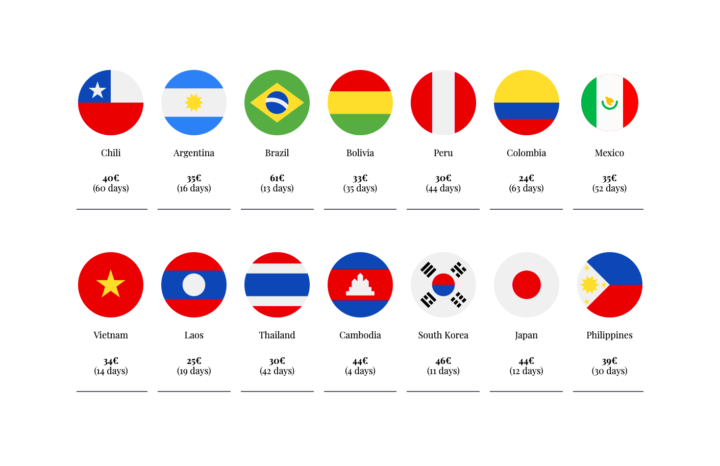
Country Minimum Maximum Average Chile 20.000clp 38.000clp 31.455clp € 21€ 40€ 33€

Activities
We’ve spent 12% of our budget in:
- Patagonia: Ventisquero colgante 8500clp, Termas 20000clp, San Rafael glaciar 150000clp, exploradores 80000clp, Marmol 15000clp.
> Check the detail in the dedicated post - Atacama: Lago Tebenquiche 5000clp, Garganta del diablo 3000clp.
> Check the detail in the dedicated post - Santiago: Parque Aguas de Ramon 3000clp.
> Check the detail in the dedicated post

Extras

General
- Phone: Entel chip 1000clp, and spent a total of 13000clp in data (buy it in small stores in cash and they send you a sms)
- Laundry: 7000clp full bag / 11000clp
- Withdraw fees: around 5000clp

Looking back…
The van trip in Patagonia represent a huge part of our budget but has been balanced with the month spent at Tanguy’s place (our friend in Atacama: THANKS AGAIN DUDE!)Total spent:
– Average of 40,65€ per day per person -

Visit Atacama during CoVid
We are staying in this beautiful region waiting for the borders to open. As the main sites are currently closed, we found great alternatives and discovered new amazing places! I’ve already visited and described the main sites in a previous post, but I wanted to share here the info up to date.
Does it still worth it?
YES!! Definitely! Totally!
Even if the most famous places are closed because of the CoVid crisis (see the detailed list bellow), you can still enjoy this amazing region, renting a car or taking tours with Horizonte Atacama which is a new company owned by great guys I know – you can say you know me 😉
Tourism is coming back slowly, so we were mostly all alone during all those trips, perfect timing!
How many days?
You should stay at least 5 days to do everything’s mentioned in this post:
- Day 1: Vallecito, the magic bus and Valle de Arcoiris (rainbow valley)
- Day 2: Salar de Atacama with Ojos del Salar and Laguna Tebenquiche, and Piedras Rojas
- Day 3: Cactus Valley in Guatin and baths of Puripobre
- Day 4: Paso Jama, Monjes de Pacana and Salar de Tara
- Day 5: Geisers del Tatio, San Pedro and Catarpe
Valle de la Luna closed: Choose Vallecito!
Valle de la Luna access is now controlled and closed, but you can take an alternative path via road 23: Vallecito. The access is officially forbidden, but we left our car before seeing any warning sign. We walked around 6km to enjoy the view on the cliffs and went to see the Magic bus. You could drive or walk more, only need is water, hat/cap and solar cream! I advise you to start the day with this trekking and keep going to Rainbow Valley the same day.
Valle Arcoiris
To find it it’s easy: after Yerbas Buenas and the Petroglyphs (still closed) the road goes down to a bridge, and you need to take the road on the left BEFORE this bridge! You will drive around 3km into the canyon, passing small rivers and arriving to the first green mountains where you will need to turn left. You can go freely in this canyon following the road (doesn’t take long but really worth it).
Salar de Atacama and Piedras Rojas

Mirador Aguas Calientes close to Piedras Rojas From San Pedro you can go south (Toconao direction) and start your trip visiting the Eyes of the desert – los Ojos del desierto (two big holes in the middle of the earth). You will pay the entrance (5000clp cash or credit card) and go to Laguna Tebenquiche. If you have time you can also go to Laguna Cejar when you can swim in a salty lake (15000clp, only in the morning as the afternoon are for groups).
It’s now a cul de sac, you will need to go back to the main road and can keep going to Piedras Rojas (Toconao, Laguna Chaxa and Lagunas altiplanicas, Miscanti, are closed).
You cannot go with your car neither walking to the Piedras Rojas (COVID) but you can still enjoy a beautiful view from the miradors by the road, and go to Laguna Toyaito and Laguna en Salar El Laco (near the argentinian border, still closed).
Note: You should prepare a sandwich as Toconao and Socaire are the only cities you will cross, and they are closed for Covid reasons.
Cactus Canyon
Before having a break in the nice baths, you should totally visit the Guatin Canyon, also known as Canyon de los Cactus and Cascadas Escondidas. When you come from San Pedro, you will find a small path right before Guatin, on your left (you will see the cactus anyway).
We walked 6km but couldn’t reach the end of this valley. We were there at the end of the day but for a better light I would recommend to go in the morning.
Termas de Puripobre
Once you’re tired of walking you can enjoy natural baths: termes. Because of the COVID, the baths you can find in Puritama must be booked and it costs 120000clp.
You have a magical alternative you should enjoy while it’s free: Puripobre. Passing Guatin, on the way of the Geisers, you will find this amazing Quebrada Escalera full of reeds and small waterfalls. After 20min walking you can freely enjoy it as there are plenty of baths with hot water.
Paso Jama
If you take East you will reach 4820km high and discover new landscapes! You will pass Quebrada Quepiaco, and can recognise the Monjes de Pacana entrance with the head of the Indian (a huge stone you will see on the left of the road). You can keep going to the Argentinian border, where you discover the Mirador Pacana Caldera, Laguna Quisquero, and the mirador of Paso Jama.

Lago Verde 
Monjes de Pacana 
Paso Jama Mirador 
Salar de Tara Geisers of Tatio
To go to the Geisers without having 1000 tourists with you, you shall arrive before the sunrise or later. I did both and I recommend early in the morning to really appreciate the effect of those Geisers and the big smoke towers they make! I also heard that it can be cool for the sunset… Usually you can even take a bath there but it’s still closed (Covid again).
San Pedro & Catarpe
Back to the city you can visit the center, enjoy the handcraft market (on the main place), eat a nice empanada or enjoy good restaurants and bars…
Near San Pedro you have Catarpe. It’s a private green land where you can currently see a nice church (visit actually closed) and Garganta Del Diablo. It’s a 8km trekking into a dry canyon leading to a huge point of view (need to climb a little, total 2h walk). You could also rent a bike in the city center!
The entrance fee for Catarpe is 3000clp and includes also an old mine tunnel and ruins actually closed. Pukara de Quitor and Death Valley accesses are also closed.
Places to eat & drink in San Pedro (doesn’t need your Pase de Movilidad but sometimes your ID):
– Adobe, great atacamenian food
– Emporio Andino for their empanadas
– Jardin Mareki, nice terrasse!
– Roots for a nice Sangria
– La Picá del Indio, cheap and fast
Geisers del Tatio 
Mirador of Garganta del Diablo To buy supplies in San Pedro:
The only mini market is located on Camino del Inca street, called Ketal.
Summary of what is open and closed as of today, December 16th 2021
South:
- Valle de la Luna: CLOSED but you can visit Vallecito and the Magic Bus instead
- Salar de Atacama: OPEN except Laguna Chaxa – 5000clp for Tebenquiche + Ojos, 15000clp Laguna Cejar
- Cities of Toconao and Socaire: CLOSED
- Lagunas Altiplanicas: CLOSED
- Piedras Rojas: CLOSED but you can still go to the miradors
East:
- Salar of Tara: CLOSED
- Monjes de Pacana: OPEN
- Uyuni tours: CLOSED
North:
- Pukara de Quitor: CLOSED
- Catarpe: Only the church and Garganta del diablo are OPEN – 3000clp
- Baths of Puritama and Puripobre: OPEN
- Geisers of Tatio: OPEN (but cannot access to the baths) – 15000clp
West:
- Petroglyphs of Yerbas Buenas: CLOSED
- Valle Arcoiris: OPEN
- Valle de la Muerte: CLOSED
- Piedra del Coyote: CLOSED but you can still see the sunset on Cordillera de Sal mirador
Our best moments


Read also: “Atacama all alone” (2015 – 2016)
How to go to San Pedro from Calama
The cheapest way to arrive in San Pedro if you don’t rent a car is to go to Calama city center (around 3500clp taxi or Uber) and to get a bus: Frontera del Norte, Buses Atacama 2000 or Turbus (3500clp). Second option is to book a TransVIP (13000clp).
-

Van trip in Patagonia
We rented a van in Pucón for 16 days to discover the amazing Chilean Patagonia and its famous Carretera Austral. I’m sharing here all the good tips and what you need to know to do the same or better than us!
Best option: the van!
You will quickly learn 2 expressions of this region:
« All that runs here is the wind » and « Who hurry in Patagonia looses his time ». Both are really true: to enjoy this trip you need to have time (2 weeks is the minimum) and considering the roads, time and distance are really approximative.
We rented a Mini Van (N300max Chevrolet) which is the fastest and more convenient option in my opinion. Even if it’s officially forbidden, nobody will bother you if you do wild camping. We had electricity to charge our phones and camera, a kitchen all equipped with gaz and hot water with a 26l tank you can fill in the rivers or lakes as most of the water comes from glaciers. We even had a shower cabin, a very confortable bed made with 3 mats and curtains. No need any restaurant, camping or hostal. We spent a total of 41500clp per person per day for transportation + accommodation (check the budget).
How to go to Patagonia from Pucón:
You have 3 options:
- Take the ferry with Naviera Austral from Quellon (on Chiloe island) to Chaitén – only one per week and much more expensive than the other options (purple road).
- Take a first ferry to La Arena, and a second one from Hornopiren to Caleta Gonzalo, both with Barcazas (green road).
- Take the road going directly to Hornopiren to Caleta Gonzalo passing through Osorno and Cochamo (yellow road).
We’ve chosen the purple road to go there, but only because the ferry from Hornopiren was full (At least it gave us the chance to discover the “Great Chiloé”). We succeeded to book the Caleta Gonzalo Ferry one week in advance and went back by the yellow road.Note: When the borders are opened you can rent this same van for more time and cross Argentinian border instead of doing the way back as we did (in Futaleufu, Chile Chico or Villa O’Higgins).

1st step: from Pucon to Chiloé
We drove directly from Pucon, bought food and supplies in Puerto Varas and took a ferry from Pargua (no need to book in advance, you have one every 20min). We first visited Ancud, famous for its fortifications and went to sleep on the wild Playa Guabun 🌜. The day after we visited Dalcahue (best smoked salmon in my life) and Castro where you have those nice houses Chiloé is famous for.
Then we headed south to Quellon where you have the end (or the beginning) of the famous Panamerica: the road connecting Latin America to Alaska! We waited there our ferry to Chaitén. There is only one per week on Sunday night, and instead of leaving at 1am we left at 4am and arrived at 8.45 in Chaiten!

Ancud 
Playa Guabun 
Dalcahue 
Castro 
Quellon 2nd step: Going South!
We wanted to arrive to the end of that Carretera Austral, without a clear idea of how long time it will take so how much time we had to enjoy activities. Well, from Chaitén it took 4 days to arrive to Villa O’Higgins, taking our time and A LOT of pictures! We felt that the landscape and the weather were changing every 50km. You can start a day with rain and cold, and be in T-shirt during the afternoon! You will cross mountains, lakes, rainforests, jungles, deserts all in one day…

Close to Chaitén 1st day: Chaiten to Lago Las Torres
We stopped on Palena river belvedere for coffee and breakfast, La Junta where everything was closed, Puyuhuapi to get lunch and Lago Las Torres to sleep 🌜.
We thought we would get much more south but the traffic was cut from 1pm to 5pm and a rock fell down the road so it opened again around 7pm! Then you have this crazy portion of road after Queulat Fjord we called « death road » with automatic traffic lights where you will wait 20min…

Cerro Castillo valley 2nd day: Lago Las Torres to Cerro Castillo valley
After fill in the tank at Villa Maniguales, we kept the Ruta 7 road to Coyhaique with again a complicated road where you CANNOT go fast (we preferred to take road X50 on the way back but it was very beautiful)!
We had a lunch in Coyhaique, « capital of Patagonia » (of Aysen region at least) and kept going south passing through a fantastic valley around Ibáñez river.
A bit after Mirador Cuesta del Diablo you won’t find any correct road and you really need to be careful. We found a spot to sleep in the forest, 1h30 before Puerto Rio Tranquilo 🌜.

Lago General Carrera 3rd day: Puerto Rio Tranquilo to Rio los Nadis
That day we discovered the huge General Carrera lake (shared with Argentina, it’s the 2nd biggest lake in Latin America), but also Puerto Bertrand and the wonderfull Baker River (the most powerful of Chile) with Mirador Confluence, Rio del Salto right after Coyhaique, and slept close to Rio Nadis 🌜.
Close to Mirador Confluence you have the entry of Parque Patagonia where you can see lamas and if you’re lucky: Pumas!!
> See more pictures on Facebook

Tortel 4th day: Rio Nadis to Villa O’Higgins
In the morning we stopped at Cochrane for gazoline and went to Caleta Tortel to get lunch. This beautiful peatonal city is a MUST DO because of the 7km wooden paths. Right after we went to Puerto Yungay and get the free ferry to Villa O’Higgins. We went to the end of the Carretera Austral and found a spot to stay at night close to Lago Cisnes 🌜.
Ferry to O’Higgins: From Puerto Yungay to Rio Bravo (45min) free. No booking needed but the first arrives get to the boat so if you want to be sure to get there you should come at least 1h in advance (only few boats per day: check the timetable).
Step 3: Going back North
5th day: Villa O’Higgins to Lago VerdeWe took the first ferry at 11am and went to Cochrane to enjoy the Belvedere. We almost get stuck with an other traffic interruption from 3pm to 5pm, but we managed to pass. We took the direction of Chile Chico, went to see Los Maquis Waterfall and stopped at Lago Verde Mirador for the night 🌜
6th day: Cuevas de las manos
We stopped at Chile Chico to get some supplies and went to the trek of Cuevas de las manos (7km). Here the landscape turned to a desert, dry and red mountains with a lot of wind. The road to get there is impressive, by its beauty and its danger (close to the cliff).
🌜We slept at Puerto Guadal that night.
Good tip: you also have a ferry crossing the lake from Chile Chico to Puerto Ibáñez (but we couldn’t get ticket on Barcazas).


Road close to the ferry at Rio Bravo 
Road to Chile Chico 7th day: Catedrales de Marmol
When you arrive at Puerto Rio Tranquilo Harbor you will have tour operators everywhere with the same price:
– 150000clp for the 90min tours which leads you to Marmol Sanctuary
– 30000clp for 3h tour with the sanctuary + the island Panichini
– 40000clp for the kayak tour (you will go to Puerto Marmol where you can rent directly there those same kayaks for 30000clp)
After this beautiful tour we went to sleep at Lago Bayo 🌜.8th day: Exploradores trekking
We booked this tour at Puerto Rio Tranquilo and met them directly in the CONAF entrance, 52km from there. We started this trekking with a group of 7 people and walked the first 1h30 through a forest and ice field. After we learnt how to walk with ice grippers, we went to various funny spots, ice tunnels and caves to take pictures. We walked 7hours (12km) and slept at the Harbour of Bahia Exploradores 🌜
9th day: Glacier San Rafael
We also booked our tour in Puerto Rio Tranquilo and met them at the harbour. We were 19 people on this very confortable boat equipped with tables and kitchen. We passed almost all our time with the captain and arrived after 3 hours sailing on the rivers and fjord to Laguna San Rafael where we appreciated the beauty of this glaciar during 2h. We had a good breakfast and lunch on board, everything included, even the whisky with millenium ice! We found a river close to an Orange Bridge to sleep in the valley of Cerro Castillo 🌜
CONTACT AND PRICES
– Glaciar Exploradores: Huenteco agency for 80000clp with a group.
For a private tour contact our guide Thiara +56968246944
– Laguna San Rafael: Kawescar agency, 150000clp to 170000clp (tranfer included from Puerto Rio Tranquilo)10th day: Coyhaique and Puerto Aysen
We stopped at this capital of Patagonia and had lunch to the best burger restaurant and brewery Casa Tropina. Sadly the Dolbek tavern was closed but you can meet there the famous Belgium guy who appears on the bottle! We quickly passed to beautiful waterfalls before heading to Puerto Aysen. Nothing really to see there, I would advise you not to loose your time and fuel… We went back to sleep at Lago Verde 🌜
11th day: Termas del ventisquero
The plan was to go to the ventisquero colgante glaciar but when we arrived around noon it was all cloudy and the CONAF girl told us it would be better to come back tomorrow and she gave us this great tips: enjoy hot water of Termas del Ventisquero. The entrance is 20000clp and you have 2 slots possible: 10h-13h or 14h-17h. It’s kind of small with only 3 baths and 1 swimming pool but the view on the fjord really worth it, and we even had the chance to see Toninas: Chilean dolphins! We slept close to the entrance of Ventisquero Colgante 🌜


12th day: Ventisquero Colgante, Futaleufú & back to Chaitén
Part of the Queulat Parc, this glacier on top of a mountain has that particularity to have magnificent waterfalls! We went to the Mirador, 7km go and back through what looks like a rain forest (2-3h walking). You also have a nice view from the lake (only 1km walking total) where you can take a boat for 10000clp (don’t know if it worth it, we decided not to go).
At 3pm after the lunch we decided to go until Futaleufú. Back to a shitty road… 77km in 2 hours! It was beautiful with nice blue river, but not as much as Puerto Bertrand. But again maybe it’s because we didn’t have time to really enjoy the countryside.
We went back to Chaiten to sleep there 🌜
You need to book and download your ticket via asptickets.cl BEFORE arriving as there is no signal.
Entrance fee: 8000clp per person13th day: Ferry’s day
From Chaiten to the harbour the road was very bad but the landscape very beautiful! We needed to be there 2h before the boat departure (don’t know why as we started to enter in the ferry 10min before take off). You will have a first quick ferry from Caleta Gonzalo to Pillan (45min) drive 9km to Leptepu to get the second ferry to Hornopiren (3h30) for a total 5 hours trip!
We drove almost 3h to Cochamo that day and slept close to a river 🌜.


Step 4: Region de los lagos
We spent the last day of our trip enjoying the beautiful volcanos and beaches you have all around this lake region. We had lunch at Puerto Octay, went to a lava river close to Lican Ray and slept on its Playa Chica 🌜


TIPS: – To stay in Pucon: Casa Mario, a REAL Chilean house where you will find the most friendly and helpful family with Veronica and Luis owning it. Only 10000clp per night per person with kitchen and private rooms. Contact: +56976457893
– To rent a van: Chile-Campers owned by Vincent from Aguaventura. Contact: +56998620879
– Apps to download before your trip: iOverlander to find places to camp + MapsMe to get the map without connection (best operator is Entel but still you will only have signal close to cities)
– To book the ferry: NavieraAustral.cl and/or Barcazas.cl
– To book your entrance to the national parcs: asptickets.cl
– To get gaz: you have only gaz stations in the main cities (I advise to fill in almost each time you see one!)
BUDGET for 2persons: Total we spent 129.000clp/day (64.500 per day per person) all included:
– Van rental for 16 days: 792.000clp total (706000 for 15days + a supplement of 1 day 52000 + supplement for our 220km extra + 6000clp for the gaz we used)
+ Gazoline: 327000clp (4220km)
+ 3 Ferrys: 13000clp (to go on Chiloe island) + 128000 (Quellon-Chaiten) + 41000 (Caleta Gonzalo-Hornopiren = 182000clp
+ Toll Pucon-Chiloe and Osorno-Pucon: 13600clp
+ Car wash: Eltit mall in Pucon 20000clp
=> 83000clp/day for the transport + accommodation as we were sleeping in our van + Food, drinks, supplies: 182000clp (supermarkets in Patagonia are expensive and empty, I really advise to buy everything in Pucon or Puerto Varas) + Activities (parc, tours, termas): 547000clpWhere we‘ve slept


Map of Ruta Austral
-

Rapa Nui / Eastern Island
To celebrate my 30 years old I was on this mysterious island, one of the most isolated, with my mom. In 4 days we achieved to visit the majority of the sites. It’s one of my favorite trip and defintly my best birthday ever!
Rapa Nui
Eastern Island, or the polynesian name “Rapa Nui” is a small island lost in the middle of the Pacific. Discovered on an eastern day, by a dutch group in 1722, it’s an island full of Moais, those enigmatic statues built between 1250 y 1500 AC.
We rented a car to visit the island and enjoy the time there all alone. You need to know that every Moai stand up have been restored, as they were all destroyed. Some of them wear a hat, others coral eyes.
You must buy at the airport a ticket to visit two sites: Rano Kau and Ahu Tongariki. The others are free (for this moment).
Tips:
To stay: Camping Mihinoa, good price and good location!
To see absolutely: Balet Cultural Kari Kari (check the video on Youtube)
> Download the map
Day 1 – South East Coast
We started the day by Vinapu, where we saw the first destroyed Moais but also the incredible work on the hats and on the platforms (very close to the peruvian style around Cuzco). Then we took the coast road and stopped at every point.
The main sites:
Vinapu

Hanga Te’e

Akahanga

Ahu Tongariki

Day 2 – Rano Raraku, North Coast & Orongo

After seing the sunrise back to Ahu Tongariki, we went to the mountain where were built the Moais: Ranu Raraku. You can see there 397 moais, including in the heart of the volcan! They were dug directly in the rock, and put in a hole to build the back side. They all have been abandoned in the middle of their construction or during the transportation. To protect them the archaeologists left the bodys in the earth, but you can easily imagine the size of the statue watching the heads!
We kept going north to find various sites, like the petroglyphs of Papa Vaka, the stone Pu O Hiro (a natural trumpet), the red beach Ovahe,Te Pito Kura – World numbril, and finished on Anakena beach where you see the Ahu Nau Nau.


Orongo

Orongo situated on the south west is a big hill where you can appreciate a gorgeous sunset! You will start by Rano Kau belvedere, view on the crater full of water, and walk along the coast seing the original Orongo houses where started Tangata Manu celebration, “Bird Man”.
Each village chief chose his champion to perform the competition (the winner offer to his village the repartition of the island supplies during one year). The competition consisted of a race starting in the crater, then they had to swim on a board to Moto Nui island (you can see in front of Orongo). Finally they had to find a tern egg and to go back on the coast with the egg intact!
Day 3 – Around Hanga Roa & the West Coast
Hanga Roa is the only city where you can visit there a nice museum, the church (you should go there during a mass where they mix christianism and local traditions and songs), and an artisanal center.
Close to the city:
Ana Kai Tangata

A cave with birds draw on the ceiling!
Ahu Vai Uri

Situated on Tahai site, Ahu Uri and Ahu Tahai are a great place for the sunset!
Ahu Ko Te Riku

Also on Tahai place, this Moai is the only one who kept his eyes!
Hanga Kio’e

An other alone Moai back to the see!
The caves

On the west coast you’ll find the cave Ana Kakenga, with two windows on the sea (hard to find because the hole is small) and Ana Te Pora a bit further.
Ahu Akivi

The only site where the Moais seems to look on the beach (the others all look inside of the island).
Huri A Urenga

A Moai with the particularity to have 4 hands.
Puna Pau

The place where come from the hats: Pukaos.
What you can ear in the church on sunday…
What you can see in the city (Playa Pea)…
If you have more time:
– There’s a Moai in the sea: go diving!
– We didn’t have time to go on the North side west side where you can go by feet
– You can do a trekking to Terevaka Volcan (507m) or Volcan Puakatike (370m)
– The best period to go there is during february for the Tangata Manu celebrationsPictures of the best moments!


-

Atacama all alone
Atacama is a region situated in north of Chile, less than 2 hours flight from Santiago, I’ve been there various time and always prefered to rent a car instead of taking a tour.
Desierto de Atacama
First I’d like to reassure you, it’s very easy to orientate yourself in this desert. You have Calama, the airport city, at 1h30 of San Pedro which is the main « city » and the starting point of all the tours. But as I always say, groups are not for me so I always rented cars from Calama to enjoy the desert alone with my friends!
From San Pedro:
South:
– Valle de la Luna
– Salar de Atacama
– Cities of Toconao and Socaire
– Lagunas Altiplanicas
– Piedras RojasEast:
North:
– Pukara de Quitor
– Garganta del diablo
– Puritama Therms
– Geisers of TatioWest:
– Petroglyphs of Yerbas Buenas
– Valle Arcoiris
– Rio Grande
– Valle de la Muerte
– Piedra del CoyotePetroglyphs of Yerbas Buenas & Valle Arcoiris
I will always remember the first time I took the car from Calama to San Pedro with my friends, crossing the field of aeolians and getting deeper and deeper in the middle of nowhere… Before arriving to San Pedro we took the road on the left direction Rio Grande and stopped to the Petroglyhs of Yerbas Buenas.
On the sunset we went to Valle Arcoiris (I’ve been there a few time, I think the best moment of the day for the colours is in the morning). To find it it’s easy: after Yerbas Buenas the road goes down to a bridge, you need to take the road on the left BEFORE this bridge!
If you have time you can go to Rio Grande which is a nice village lost in the mountains.

Petroglyphs yerbas buenas 
Valle arcoiris Salar de Atacama, Lagunas Altiplanicas & Piedras Rojas

From San Pedro we took our car direction south (Toconao – Solaire) and start our trip seing the sunrise on the lake Tebenquiche, then we follow the road to pass in front of the Eyes of the desert – los Ojos del desierto (two big holes in the middle of the earth), and arrive to Laguna Cejar when you can swim in a salty lake (for me it doesn’t own the price).
After that, it’s a cul de sac, you will need to go back to the main road and can take a break to Toconao (not a lot to see but a small church and the stairs of the bell tower made of cactus wood ! – try to be there at noun it’s still a manual bell) and then direction to south, turn on the first to the right until Laguna Chaxa which is the supposed favorite place for the flamingos. You’ll find there a small museum about the desert fauna et flora, and you can enjoy a nice labyrinth of paths through the salty desert.
We came back again to the main road, and took direction Solaire to go to Lagunas altiplanicas (Lagunas Miscanti and Miñiques). We came back to the main road again and took direction to Piedras Rojas. To be true we didn’t make it the first time (not enough fuel) but you should definitly end this day seing the sunset there!
San Pedro, Pukara de Quitor & Valle de la Luna
Back to the city we visited a little bit the center… Enjoy the market (entrance on the main place), eat a nice empanada, buy some fruit or vegetables on the car park… You can also visit the museum of meteorite (never did) and a nice church!
Very close to San Pedro there is a lot of stuff to see: you can start by Pukara de Quitor (Atacamanian ruins), it’s just 5 min drive from the city center and it gives you an amazing view of the Death Valley.
Valle de la Luna MUST be in your todolist!
Places to eat & drink – Burger Garden, a food truck – El Huerto & his garden behind – Casa de Piedra, nice restaurant! – 02 for a good breakfast or tea – ChelaCabur for a good beer – Barros and his live music – Lola’s to take a drink – Ayllu and his terrasse with fire
Here are what you can see in this Moon Valley:
Canyon

Dune

Anfiteatro

Las 3 Marias

Around San Pedro you can also lost yourself in the Garganta del Diablo, or go to Valle de la Muerte – Death Valley – to do Sandboard (there’s not more to do there…).
Salar de Tara

Here you will go to the highest point, more than 4300m, I’ve been there twice, one with a 4×4 with a friend but we almost lost ourselves in the desert, so the second time I booked a tour with Horizonte Atacama Agency. You will start at 7am and end around 4pm, totally dead…
You will first stop at Rio Quepiapo, then you will enter in the desert and have few time to see the Monjes de Tara. They’re old volcan projectiles, very impressive… Then you will stop on a huge crater, and go to Tara’s Cathedrals to have lunch in the border of a lake before coming back.
Geisers of Tatio & Termas de Puritama

To go to the Geisers without having 1000 tourists with you, you shall arrive before the sunrise or later (around 8am). I did both and I recommend early in the morning to really appreciate the effect of those Geisers and the big smoke towers they make! I also heard that it can be cool for the sunset… And I’ve never did it but you can even take a bath there!
You can also wait until Termas de Puritama to swim, it’s a really nice place, an oasis in the middle of the desert with great installations!
“Get lost in the Nature and you will find yourself”
Time for each activity: – Valle de la Luna: 3 hours to visit – San Pedro to the Geisers: 1h30 – San Pedro to Termas Puritama: 30min – San Pedro to the Atacama Salar: 45min – San Pedro to Toconao: 30min – San Pedro to Piedras Rojas: 3h
Prices (in pesos, for foreigners): – Valle de la Luna entrance: 10000$ – Geisers entrance: 10000$ – Termas de Puritama entrance: 11000$ – Laguna Cejar entrance: 25000$ – Tour of stars: 30000$ – Tour of Salar de Tara 40000$
Looking back…
– The most beautiful part is beyond the Piedras rojas, you will see amazing lakes full of Flamingos and colored mountains
– Never did: minas de Chuquicamata, the biggest with open sky! You need to book in advance and to start from Calama.
– The only tours I would recommend are for the Salar de Tara, Volcan Licancabur (5920m) and Salar de Uyuni (in Bolivia)
– Best sunset: at Piedra del Coyote (included in the entrance of Valle de la Luna)
– I fully recommend a star tour, but with lot of clothes and more than one telescope for 10 people!Thanks all of you for sharing those great landscapes…


-

What to do in Santiago
I lived almost 3 years in this city so I know it pretty well, and lived my best years there! Between Europe and Latin America, you can find everything in this modern city, but for a tourist I would just recommend few days there, as Chile is very different from its capital!
The historic center
Let’s start by the old center. Take the metro line 1 (red one) and stop at Santa Lucia. Here you will find two artisanal markets: the craft center (perfect to buy souvenirs) across the main road, and an other at the entrance of Santa Lucia hill. You can enjoy a very nice view from the top, and go back down to take San Antonio pedestrian street. There’s a lot of shops and restaurants in this area. Take North direction and you will arrive on the main place: Plaza de armas. This is the km 0 point of Chile. On this gorgeous place surrounded by galeries, you can visit the cathedral, the old post office, and the city council where you can climb on the clock tower to get a general view of the place, and enjoy the museum of the city! I also recommend you the pre colombian art museum – el Museo Chileno de Arte Precolombiano.
Let’s keep going North until the Mercado Central, perfect place to eat fish and sea food. If you like local stuff you must absolutely go to La Vega market crossing the bridge! The paradise of vegetables, fruits and spices… Cross back the bridge and walk along Florestal parc until Bellas Artes museum. Here take on the right and finish this big walk in Lastarria, the latin quarter full of terrasses to take a nice break. If you like opera, I suggest you to visit the Municipal Theater also in the center!

Cerro Santa Lucia If you have time…
La Moneda
The president building destroyed by the Pinochet bombing in 73, and where Salvador Allende committed suicide. You also have a cultural museum to visit and the biggest flag of the country on this place!
Barrio Yungay
This old quarter full of street art where you can visit an impressive human right museum: el Museo de la Memoria y de los Derechos Humanos. Take time also to discover the street Concha y Toro.
San Francisco church
This red church is the first and oldest colonial building of the country. You even can see there a chapel for domestic animals!
Paris Londres
Two very nice streets with a european style close to the craft market (centro artesanal) of Santa Lucia.
Barrio Italia
Situated south of Salvador Metro, calle Italia full of galeries and coffee shops is a perfect place to walk during the week end.
Los Dominicos market
At the end of line 1 of the metro is a nice artisanal market in the feet of the Cordillera.
Places to eat:
– Liguria, chilean food and nice restaurants (metro Tobalaba or Manuel Montt)
– The terrasse of Biografo in Lastarria, food is not crazy but it’s nice and quiet
– Peluqueria Francesa with great deco in Yungay
– Castillo Florestal in front of Bellas Artes
– Mathilde’s rooftop for the sunset in Bellavista
– Silvestre in Barrio Italia for a sunday brunchTo take a drink:
– Maestra vida, a salsa bar
– Bar a cielo Abierto for colombian live music
– Jardín Mallinkrodt, a nice patio
– The Thelonius in Bellavista, a jazz bar
– The Roof (or others on Tobala avenue)
– Santo Remedio or other bars on Manuel Montt
– Bar de Rene Barrio Italia, a rock bar with cheap piscolasFrom top to underground
The highest tower of latin america is located in Tobalaba, in Costanera Center! You should choose a day without “smog” (the pollution cloud), the day after a rain is perfect for that. You could walk from the tower along the Rio Mapocho to Pedro de Valdivia Norte and take the teleferic to go on top of San Cristobal hill, to the Virgen. To go back down you can take the “elevator” and arrive to Pionono street: the perfect place to take a drink. You can or choose one of the terrasse on the street and enjoy cheap beers and fries “namedekoi” or go to Patio Bellavista, much more “high level”.
Looking Back…
Santiago is nice to visit two or three days, but you better go out from the capital as soon as you can. You can find places around the city, take North to La Serena and Valle de Elqui, or go to Atacama region, or take South to the lakes region around Pucon and Puerto Montt, go to Chiloe Island, or take the Carretera Austral to the great Patagonia, or a flight to Punta Arenas to visit Torres del Paine parc and the glaciers.Close to the city…

The Cordillera
Cerro Manquehue, Manquehuito, Pochoco, Santuario de la naturaleza, Aguas de Ramon… You have plenty of places 30min from the city center to lost yourself in the nature and escape from the polluted center! To ski you shall go to Valle Coronado or Nevado.

Pommaire
This small village is a nice break and can be a stop to do before going to Valparaiso! Famous for its poteries you can buy very cheap stuff and enjoy great typical chilean food!

Valparaiso
UNMISSABLE! Full of stories, this hippie city has a collection of street arts. You can pass a week end there taking a bus from Universidad de Santiago.

Vineyards
Santiago is surrounded by great vineyards like Concha y Toro, or Emiliana (an organic one) you can visit with a guide and vine degustations.

Cajon de Maipo
If you like green places, rafting, trekkings, or hot baths, I fully recommend you to go there (by car for more liberty)! You should visit the website to get all the informations!
Pictures of the best moments!


![[VIDEO] Ruta Austral](https://lookbackpacker.com/wp-content/uploads/2022/08/34E5D072-2ACF-4723-A345-E10E9A71B840.png)